


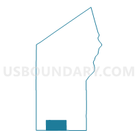
CABLE - T 1 Voting District, Bayfield County, Wisconsin
About
Outline

Summary
| Unique Area Identifier | 692352 |
| Name | CABLE - T 1 Voting District |
| County | Bayfield County |
| State | Wisconsin |
| Area (square miles) | 71.42 |
| Land Area (square miles) | 69.35 |
| Water Area (square miles) | 2.06 |
| % of Land Area | 97.11 |
| % of Water Area | 2.89 |
| Latitude of the Internal Point | 46.20161980 |
| Longtitude of the Internal Point | -91.30490520 |
Maps

Graphs
Select a template below for downloading or customizing gragh for CABLE - T 1 Voting District, Bayfield County, Wisconsin


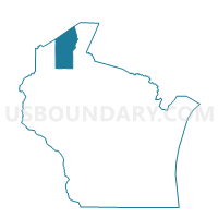
Neighbors
Neighoring Voting District (by Name) Neighboring Voting District on the Map
- BARNES - T 1 Voting District, Bayfield County, WI
- DRUMMOND - T 1 Voting District, Bayfield County, WI
- GRANDVIEW - T 1 Voting District, Bayfield County, WI
- LENROOT - T 2 Voting District, Sawyer County, WI
- NAMAKAGON - T 1 Voting District, Bayfield County, WI
- SPIDER LAKE - T 1 Voting District, Sawyer County, WI
Top 10 Neighboring County Subdivision (by Population) Neighboring County Subdivision on the Map
- Lenroot town, Sawyer County, WI (1,279)
- Cable town, Bayfield County, WI (825)
- Barnes town, Bayfield County, WI (769)
- Grandview town, Bayfield County, WI (468)
- Drummond town, Bayfield County, WI (463)
- Spider Lake town, Sawyer County, WI (351)
- Namakagon town, Bayfield County, WI (246)